Photo Notes, Top to Bottom:
7/2/23 Reykjavic is the most northern capital of the world, and the "Harpa Concert Hall" as one of its main attractions which opened in 2011. Not to be missed, (and only a few streets away), are the most famous hot dogs in the world known as Bæjarins beztu pylur (which translates: "The Best Hot Dog in Town") are THE BEST IN THE WORLD! They are made with deep fried onions, Val's tomatatsosa (sweet ketchup), a yellow-orange-brown sweet mustard, and remola, a mayonnaise-based sauce with sweet relish. What great tasting junk food and not sloppy to eat . . . just ask Bill Clinton! Cost: Two for $5.00 www.bbp.is/en
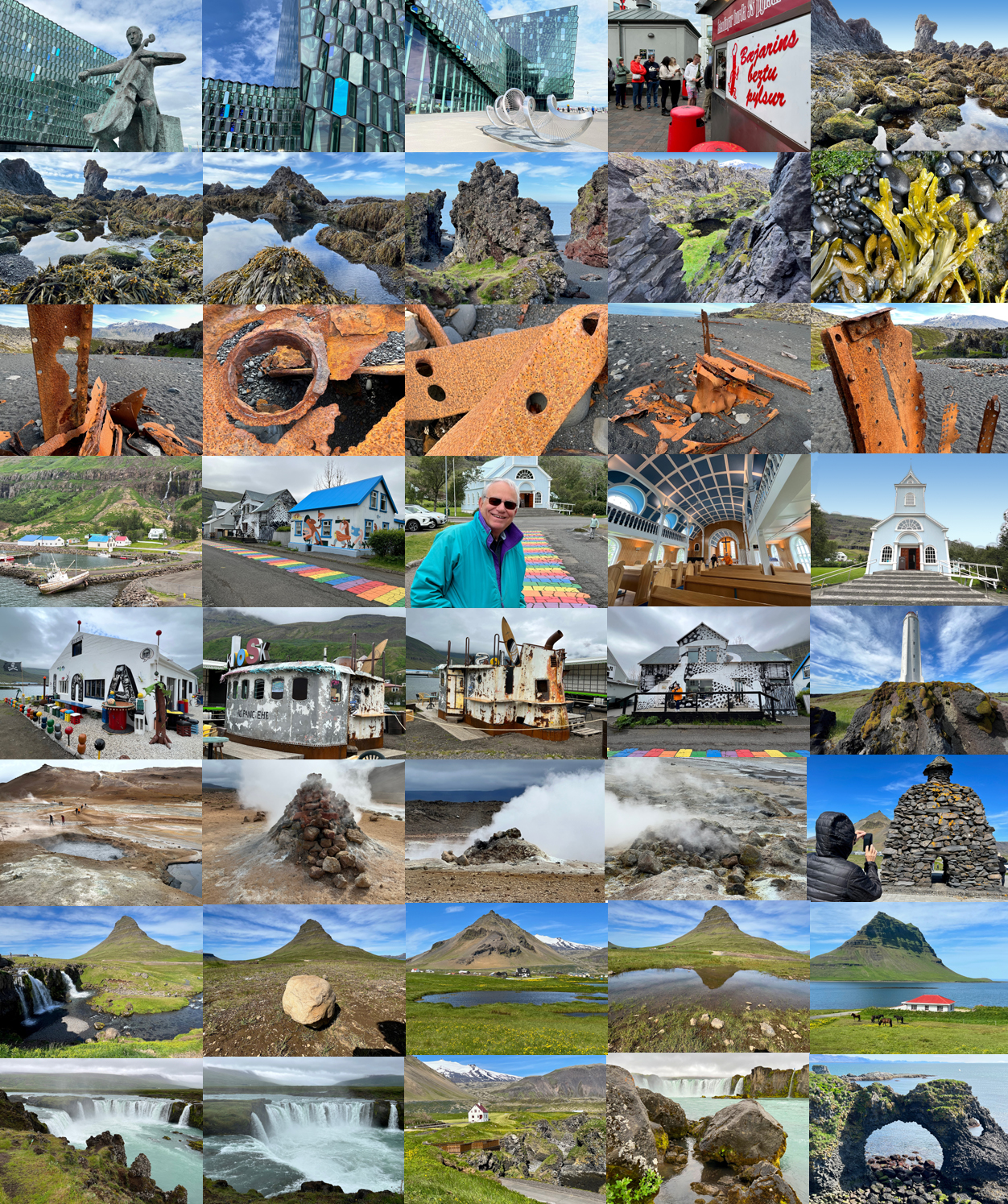
7/3/23 Bay of Djupalonssandur/(Dritvik). The largest of the rocky lava formations at Djupalonssandur; "Songklettur," is said to be an elf church. The iron remains on the beach are from the British trawler, the "Epine GY7" which was wrecked east of Dritvik on the night of March 13, 1948.
7/6/23 Seydisfjordur, Iceland. This charming town is located in the eastern part of Iceland, nestled among towering mountains, surrounded by the sea with a very rich cultural heritage and thriving arts and music scene. The picturesque harbor is considered one of the most beautiful in Iceland. The town hosts many exhibitions and musical events throughout the year - in the church. Noticed the iconic rainbow stones in the middle of the street.
7/5/23 Skutustaoahreppur/Namafjall is a high-temperature geothermal area with fumaroles and mud pots. At a depth of 3,000 feet, the temperature is above 200 degrees Celsius. Cold ground water seeps down to magma intrusions, where it is heated and transformed into steam and then comes back to the surface. Along with the steam comes fumarole gas which contains sulfur hydroxide which is responsible for the hot spring smell. In hot spring areas, sulfur deposits are formed when fumarole gas mixes with air. Besides the sulfur deposits, a mixture of silica and gypsum forms around the fumaroles. In mud pots, fumarole gas rises through surface water, producing sulfuric acid, which makes the water acid. Rock and soil dissolve in this acid water, producing the mud which is typical of mud pots. Centuries ago, sulfur was mined in Iceland to produce gun powder.
7/5/23 Fossholl/Godafoss waterfall is one of Iceland's larges waterfalls and is fed by a 180 km long glacial river "Skjalfandafljot." Salmon swim up the river as far as Geitafoss. Because the soil is so shallow, only dwarf-shrubs, lichen and moss can thrive.
Enjoy this 26-minute video of our Iceland/Greenland expedition cruise, please cut and paste:
https://download-video.akamaized.net/2/playback/cd77df36-8f35-4669-9f3c-df123ebca7a4/b86ed1f4-632ef7dd?__token__=st=1689781088~exp=1689795488~acl=%2F2%2Fplayback%2Fcd77df36-8f35-4669-9f3c-df123ebca7a4%2Fb86ed1f4-632ef7dd%2A~hmac=720698225c73ffc391b0ade37bec9de4697d710b693d788ae92ab364ac8a0383&r=dXMtY2VudHJhbDE%3D
If you have ever wondered what the moon is like - come and visit Iceland, an explorer's destination. The peak season is from June to August, but the bargain months are April and May, September and October. If the Northern lights fascinate you, then the winter months: (September to April) is the time to visit. Iceland is about the size of the state of Virginia and offers 24 active volcanoes. Not to be missed is "The Golden Circle," which includes the Blue Lagoon, Gullfoss, Skogafoss, the Thingvellir National Park and of course the magnificent Geysirs, (Geisir), which just happens to be an Icelandic word.
Iceland is famous for:
Puffins
Geysers
Glaciers
Ice caves
Volcanoes
Waterfalls
Hot springs
Two tectonic plates
Black sand beaches
Everyone speaks English
Lava fields - many covered with moss
The Northern Lights ~ (Aurora Borealis)
Cod, Cod, Cod - and other fresh seafoods
The most famous (and best) hot dogs in the world!
There are twenty-nine recorded marine mammal species
8 Baleen whales, 14 Toothed whales, and 7 Pinnipeds (seals)
The world's smallest/unique horses (bred for over 1,000 years)
The country which produced THREE "Miss Universe" winners
The Icelandic language - the second most difficult language in the world
Iceland and Greenland are rapidly becoming Europe's hottest destinations. Much of Iceland's popularity is due to its natural features, which include glaciers, hot springs, geysers, active volcanoes, portentous peaks and vast lava deserts. In addition to its expansive landscape, it has a rich history and folklore tradition.
DATES PORTS OF CALL
JUL 02, 2023 REYKJAVIK, ICELAND
JUL 03, 2023 GRUNDARFJORDUR, ICELAND
JUL 04, 2023 VIGUR, ICELAND
JUL 05, 2023 Husavik, Fosshol & Godafoss Waterfalls
JUL 06, 2023 SEYDISFJORDUR, ICELAND
JUL 07, 2023 PAPEY ISLAND, ICELAND
JUL 08, 2023 HEIMAEY, WESTMAN ISLANDS, ICELAND
JUL 09, 2023 At Sea
JUL 10, 2023 ITTOQQORTOORMIIT, GREENLAND
JUL 11, 2023 East Greenland
JUL 12, 2023 East Greenland
JUL 13, 2023 East Greenland
JUL 14, 2023 East Greenland
JUL 15, 2023 East Greenland
JUL 16, 2023 REYKJAVIK, ICELAND
Descriptions of our itinerary
Grundarfjorour - Grundarfoss is one of the highest waterfalls in the West of Iceland and very impressive to see. This waterfall falls over a wall of basalt 70 meters deep, in a single drop.
The town's main industries lie in fishing and fish processing. Grundarfjorour also bears host to substantial ship traffic, a consequence of the settlement's natural harbour.
More recently, it has become a center for tourism, due to the incredible beauty of the features on the Saefellsnes Peninsula. It is developing to meet the needs of those who travel through it.
One can also find a nine-hole golf course beside the town.
Visitors to Grundarfjorour will likely visit the town's main landmark, the photogenic Kirkjufell, which translates to 'Church Mountain.' Clearly distinguishable, and standing alone on the edge of the sea, its dramatic slopes, steeple-like peak and surrounding shorelines make it one of the country's most beautiful summits.
Kirkjufell is often called the most photographed mountain in Iceland, due to the variety of different way you can shoot it, and how starkly different it appears under different lights.
Besides the mountain itself, one can find Kirkjufellsfoss (Church Mountain Falls), a beautiful three-pronged waterfall, which is often favored as a foreground.
Vigur is the second largest island of the Isafjaroardjup fjord in Westfjords, Iceland. Located just south of the Arctic Circle, the island is around 2 kilometres in length and 400 metres in width. The island is most noted for its thriving seabird colonies-particularly Atlantic puffins-traditional eiderdown production and historical buildings.
The two story Viktoriuhus, built in 1860, is one of the oldest timber buildings in Iceland and is part of The Historical Buildings Collection of Pjoominjasafn Islands. Iceland's oldest seaworthy boat, Vigurbreiour, is also on Vigur.
Seydisfjordur is surrounded by incredible nature, including mountains, waterfalls and beautiful sea views. About 17 kilometres (10.5 miles) from the town is the nature reserve Skalanes, a hub for scientific and conservationist exploration. This reserve, covering over 1200 hectares is known for its diverse wildlife, boasting 47 species of birds. Seydisfjordur, in the Eastern Fjords, is one of the most picturesque villages in Iceland, as well as one of the country's main cruise ports.
Nestled between dramatic mountains and one of Iceland's most beautiful fjords is Seydisfjordur, a tiny but beautiful town that embodies traditional Icelandic style.
History of Seydisfjordur
While there is evidence of people living in Seydisfjordur dating back to Iceland's early settlement period, the town wasn't founded until the 19th century, when Norwegian fishermen built it up as a small port. A boom in herring fishing meant that Seydisfjordur later became the most prosperous town in eastern Iceland.
In fact, many of the picturesque wooden buildings in the village have their origins in those golden years, and some were even brought disassembled over from Norway itself. You can experience a Norwegian town without leaving Iceland!
Decades later, after having served as a base for the American and British armies, Seydisfjordur entered an economic depression following the gradual recession of the herring industry. Today, the town continues to live off fishing, tourism and handicrafts, having been established as one of the main stops on cruises around Iceland.
What to see in Seydisfjordur?
The ideal plan when visit Seydisfjordur is to take a leisurely stroll through its picturesque streets and admire the surrounding mountains and fjord. Thanks to its small size, you should be able to see all of its main places of interest:
Road to Seydisfjordur: even the road itself that leads to Seydisfjordur off the Ring Road is impressive. After reaching the top of a peak, it descends through the countryside in a succession of sharp bends curving around snow-capped hills and a myriad of small waterfalls all the way down to the town. The enchanting route has even been used as a filming location for The Secret Life of Walter Mitty, starring Ben Stiller.
Blue Church: Seydisfjordur Church is one of the town's most emblematic monuments. While it's often closed, and the interior is relatively modest anyway, its unforgettable pastel blue exterior makes for a postcard-perfect view against the snowy mountain backdrop. If you're planning a trip to Iceland in summer, you can enjoy Blaa Kirkjan's summer classical concert series.
Avalanche Monument: next to the blue church is a monument to the avalanche of 1996, one of many that have affected Seydisfjordur throughout its history.
Seydisfjordur Rainbow: Seydisfjordur, like the rest of Iceland, is very welcoming of the LGTBQI community and the town's striking multicoloured tile path was painted in homage to the rainbow flag and as a symbol of respect and tolerance. The contrast of the rainbow with Blue Church makes it one of the most photogenic spots in Seydisfjordur.
Papey is an island near the east coast of Iceland in the municipality Djupavogshreppur and is about .77 square miles in extent, the highest point on the island being about 190 feet above sea level.
The island was inhabited from the settlement of Iceland, until 1966. There still is a lighthouse, a dwelling house, a church and a weather station on the island, the latter automated since 1998. There are also large colonies of Atlantic puffins on the island.
Papey is said to be named after the monks called Papar and it is mentioned in the Landnamabok as one of two places where these monks lived. The story in Landnamabok is that as Ingolfr Arnarson and his followers had lived during the winter at Geithellar in Alftafjorour at a distance from Papey, some of his women followers climbed a mountain in the spring and saw smoke from the island. When they later got a closer look and found special items there, they understood that the smoke had to have been from Papar (or quote: "Vestmen") inhabitants. There are also some toponyms on the island (aside from the island's name itself) indicating Papar monks were living there.
Heimaey is an Icelandic island. At 5.2 sq mi), it is the largest island in the Vestmannaeyjar archipelago, and the largest and most populated island off the Icelandic coast. Heimaey is 4.6 miles off the south coast of Iceland. It is the only populated island of the Vestmannaeyjar islands, with a population of 4,414. The Vestmannaeyjar Airport and the Westman Islands Golf Club taken together cover a good portion of the island. In January 1973, lava flow from nearby Eldfell destroyed half the town and threatened to close its harbor, its main income source. An operation to cool the advancing lava with sea water saved the harbor. Heimaey is home to around 4,500 people, and eight million puffins every summer. Many millions of other birds migrate there for breeding and feeding. The island is connected to the rest of Iceland by a ferry and Vestmannaeyjar Airport. Most people on the island live off fishing. During an annual festival, people are allowed to catch a few puffins to share at the festival, or to eat at home.
Eldfell At 1:00AM on 23 January 1973, a volcanic eruption of the mountain Eldfell began on Heimaey. The ground on Heimaey started to quake and fissures formed. The fissures grew to 5,200 feet in length, and lava began to erupt. Lava sprayed into the air from the fissures. Volcanic ash was blown to sea. Later, the situation deteriorated. When the fissures closed, the eruption converted to a concentrated lava flow that headed toward the harbor. The winds changed, and half a million cubic metres of ash blew on the town. During the night, the 5,000 inhabitants of the island were evacuated, mostly by fishing boats, as almost the entire fishing fleet was in dock.
The encroaching lava flow threatened to destroy the harbor. The eruption lasted until 3 July. Townspeople constantly sprayed the lava with cold seawater, causing some to solidify and much to be diverted, thus saving the harbor. During the eruption, half of the town was crushed and the island expanded in length. The eruption increased the area of Heimaey from 4.3 square miles to 5.19 square miles. Only one man died in the eruption. The eruption is described by John McPhee in his book The Control of Nature.
Some final shots of Chris Marker's film Sans Soleil are of stark white Heimaey houses slowly buried by the deep black volcanic ash of the eruption. The backdrop reveals splashes of red lava as it flows into a steel-grey sea.
Heimaey is mentioned in the song "Island" by American progressive-metal band Mastodon. The line is "Lava goddess, Ice and fire, Settling down, Ocean Geysir, Gullfoss, Heimaey 73." This refers to the eruption of Eldfell.
Keiko the whale from the Free Willy films was in real life flown to Klettsvik Bay on Heimaey as his final home before being freed.
Ashes to Dust by Yrsa Siguroardottir (2007, English Translation 2011), the third of her murder mysteries set in Iceland, is largely set on Heimaey and focuses round the Eldfell eruption of 1973, and discoveries resulting from excavation, more than 30 years later, of a house buried in the volcanic ash.
Heimaey features in Bruce McMillan's photo-illustrated children book Nights of the Pufflings (1995). In the story a tradition of rescuing young birds, pufflings, by local children is told. The pufflings take their first flight on August nights, and get accidentally stranded in the village streets. The children then set them free at the beach at daytime.
The 1973 album Sumut by Greenlandic rock band Sume features a song called "Heimaey erĸaivdlugo" (English: "Ode to Heimaey").
Akureyri is a town in northern Iceland. It is Iceland's fifth-largest municipality, after Reykjavik, Hafnarfjorour, Reykjanesaer and Koopavogur, and the largest town outside Iceland's more populated southwest corner.
Nicknamed the "Capital of North Iceland," Akureyri is an important port and fishing center. The area where Akureyri is located was settled in the 9th century, but did not receive a municipal charter until 1786. Allied units were based in the town during World War II. Further growth occurred after the war as the Icelandic population increasingly moved to urban areas.
The area has a relatively mild climate because of geographical factors, and the town's ice-free harbor has played a significant role in its history.