Yangon (Rangoon), Myanmar (Burma)
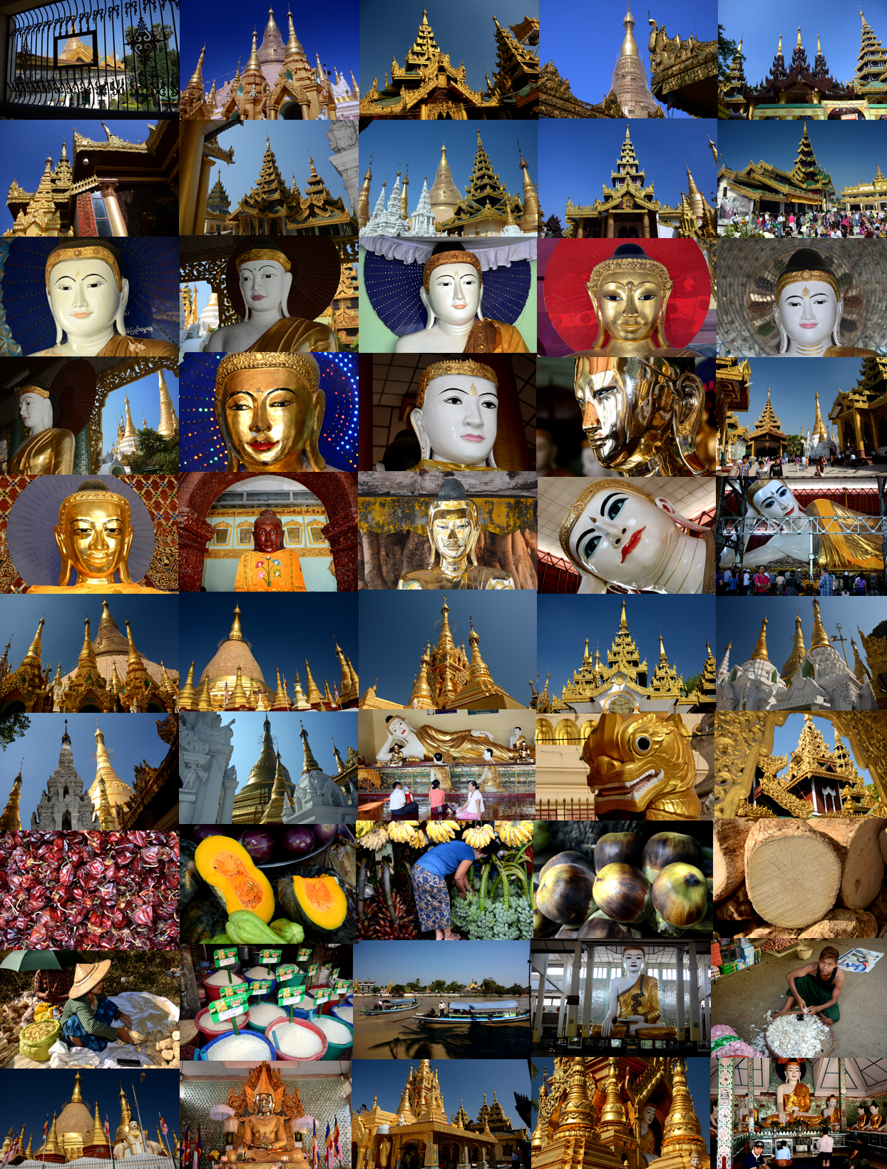
Yangon (Rangoon), Myanmar (Burma)
“This is Burma and it will be quite unlike any land you know about.” Rudyard Kipling … (Letter from the East)
Chaukhtatgyi Pagoda
The temple's centerpiece is an immense Buddha reclining in the “parinibbana” posture –the posture in which the Buddha received his enlightenment. The immense figure's head stands some 2-1/2 stories high. The breadth of the face is 38 feet. The length of the eye ball is 5-feet and 8-inches. The lips are 10-feet long. The ears are 17 feet and 7-inches long. The arms are 28 feet long. The feet are 32 feet long. The circumference of the body is 144 feet.
Myanmar
Myanmar, formerly Burma, is still under military rule. One thing is for certain, the people of Myanmar want you to visit. Money that you spend there goes directly into their hands to improve their lives. Many of the people you encounter have studied English (they have already placed their bets on Myanmar’s brighter future) and they are very happy for any contact with foreign visitors. Myanmar seems frozen in time, but expect everything to change rapidly once the country fully opens. Until then you can see Asian daily life as it existed more than a century ago. Almost everywhere that tourists are allowed to visit is going to be very safe. You must take shoes off to visit any sacred site, so consider easily removable footwear.
Women and men still wear a charming wrap-around longy - (sarong) - as standard attire and decorate their faces with pale yellow powder. The farther upcountry you go, the more colorful tribes you will encounter (“Myanmar” describes all of these various peoples, whereas the Burmese are just one of dozens of ethnic groups that comprise the nation).
Yangon is like no other city in Asia. It is the definitive setting for an exotic “far east” movie set; a bustling, dusty, and color-splashed city blending nostalgic influences from India, Tibet and Persia into its ancient cultural fabric. The people are simply amazing to look at. Classic colonial facades give way to diamond and gem-encrusted spires of zedis (temple stupas) around which daily life orbits.
Have high tea at the classic Strand Hotel, wander the shady markets in the afternoon and then head to the glimmering Shwedagon pagoda before sunset. Here, amidst prayer halls, spirit shrines, and monumental bronze bells, take a moment to sit and watch the crowd of families, tourists, pilgrims, school children, monks, nuns, and worshippers as they flow through the golden light.
Myanmar is the land with glittering golden Pagodas and is also known as Suvannabumi or "Golden Land.” The Country is unique in so far it has managed to preserve its beautiful natural environment, traditional customs and ancient cultural heritage unlike so many countries where concrete has been the order of the day. The British called the country Burma, presumably after the majority race the Bamar, but the name Myanmar was the official name of the country since at least the time of Marco Polo. Myanmar again became the official name in 1989 although some still use the colonial name Burma.
Occupying the largest area on the South-East Asian peninsula, Myanmar is one of the most pleasant places created by Mother Nature. It has an area of about 680,000 square kilometres - roughly equal to France and the United Kingdom combined - and is inhabited by a population of over 49 million people belonging to 135 national races. Myanmar shares common borders with China in the north and the north-east, Laos in the east, Thailand in the south-east and India and Bangladesh in the west. In the south-west is the Indian Ocean and Myanmar’s coastline extends southwards from where Myanmar and Bangladesh meet to the southern extremity where Myanmar and Thailand meet - making a very long coastline of over 2,800 kilometres.
Myanmar is a forest-clad mountainous country. In the northern part of the Country there are three parallel chains of mountain ranges beginning at the eastern extremity of the Himalayas and running from north to south: these are the Rakhine Yoma, the Bago Yoma and the Shan Plateau. In the northernmost extremity of Myanmar in Kachin State is Hkakabo-Razi which, at 5881 metres, is the highest mountain in South-East Asia. In the southern part of the Country there is the Tanintharyi Yoma. The northern mountain chains divide the country into three river systems: the Ayeyawady ("Irrawaddy"), the Sittoung and the Thanlwin. The Ayeyawady, the most important river, is about 2170 km (1350 miles) long, and its major tributary, the Chindwin, 960 km (600 miles): they constitute the greatest river system in the Country. As there is very little rain in the central dry zone the Chindwin and Ayeyawady rivers are very important for the irrigation and general economy of these lands, rather like the River Nile is in Egypt. As the Ayeyawady enters the sea it forms a vast delta of 240 km (150 miles) by 210km (130 miles). With these mountain chains and river systems, the country can be divided into seven major topographic regions: the Northern Hills, the Western Hills, the Shan Plateau, the Central Belt, the Lower Myanmar Delta, the Rakhine Coastal Region and the Tanintharyi Coastal Strip.
Myanmar has a tropical monsoon climate with three seasons: the hot season from mid-February to mid-May, the rainy season from mid-May to mid-October and the cool season from mid-October to mid-February. Annual rainfall varies from 500cm in the coastal regions to 75 cm and less in the central dry zone. Mean temperature ranges are from 32°C in the coastal and delta areas to 21°C in the Northern lowlands.
Myanmar is singularly the most forested in South-East Asia and is actively pursuing the prevention of the deforestation of rainforests which has occurred in most parts of the region. “Rainforest” and “Destruction” are two words which go hand in hand in most parts of Asia but this is not so in Myanmar: one only has to do a trip across the Rakhine Yoma or around the mountains of Dawei to see the plentiful abundance of the rainforest in Myanmar.
Take a trip to Myitkyina to see the world in the wild, or climb Mount Victoria in the mountainous Chin State which has recently been opened up to eco-tourism. Visit Moeyongyi Lake - a 40 square mile Bird Sanctuary - the best time to visit is from November to February when you can expect to see at least 10,000 birds! Even in the dry zone there are Nature Reserves such as Lokananda a small reserve in Bagan.
Then there is the Myaing Hay Won Elephant Camp at the end of the Bago Yoma not far from Yangon on the road to Pyay (Prome). Or the newly-created Elephant Reserve in the Rakhine Yoma between Thandwe and Gwa with an area of 678 square miles.
And now the designated Nature Reserve of Hukawng Valley has been extended to 20,000 square kilometres and will be the largest Tiger Reserve in the world.
Most of the population live in the Central Belt, (Sagaing, Magway and Mandalay Divisions), the Lower Myanmar Delta and the Shan Plateau. Seven other nationalities have States of their own. The Kachins live in the Kachin State and the Northern Shan State; the Kayahs live mainly in the Kayah State. The Kayins have mostly become intermingled with the Bamars and the Mons, while the rest live in the delta region and the lowland Sittoung Valley. The Chins live in the Chin Hills and also in the dry zone west of the Ayeyarwady; the Mons live mainly in the South-East of Myanmar while the Rakhines, who speak and write Myanmar but with a different tone and accent, have their own State which lies in the coastal region of the Rakhine Yoma. The Shans live mainly in the Shan Plateau area.
About 90 per cent of the population, mainly Bamars, Shans, Mons, Rakhines, and some Kayins, are Buddhists, while the remainder are Christians, Muslims, Hindus and Animists. The Christian population is composed mainly of Kayins, Kachins and Chins. Islam and Hinduism are practiced mainly by people of Indian origin.
Burma, Courtesy of Terry Greenberg
Current Political Situation
Phenomenal changes since 1990’s
- Tourism and foreign investment
- Overseas Burmese welcomed back
- Joining ASEAN
- Democratic reforms
But political reform incomplete
Military mindset: xenophobic, untra-nationalist
“No more interest in democracy than they could envisage democracy in the military ranks.”
RANGOON (Yangon)
In ancient times, small town, right on the coast
Modern city founded in 1755 , with Burmese defeat of Mons
Meaning “End of Strife”
1939 – 56% of city population was Indian (over 1 million)
BURMESE ECONOMY
Major Exports:
Timber, Rice, Gemstones ($2.3 billion in 2013). Narcotics: 3rd largest producer of illicit opium – 690 metric Tons in 2012
Actually export dollars are uncertain, as massive amount of product is smuggled out.
RELIGIOUS DIVERSITY
Buddhist = Thailand, Myanmar, Cambodia, Laos
Muslim – Indonesia, Malaysia, Brunei
Hinduism – Bali
Christian – Philipines
Confucian – Singapore, Vietnam
LANGUAGE DIVERSITY
Austronesian – Indonesian, Malay,Tagalog
Austroasiatic – Khmer, Mon, Vietnamese
Sino-Tibetan - Burmese, Thai
HOWEVER, MANY SIMILARITIES
Historical experiences
The Arts
Popular Beliefs
Cultural Patterns
Cuisine
Climate
Chinese Settlement
Yangon (Rangoon), Myanmar (Burma)
Island Pagoda Discovery & Horse Cart Riding Excursion:
This morning excursion will begin with a 30 minute drive to the old trading port of Thanlyin. Thanlyin was a major port and important trading center from the 14th through the 18th centuries until it was displaced by Yangon in 1755. During the 17th century, the area was briefly controlled by the Portuguese adventurer, de Brito. Ruins of some of the once glorious structures may be seen, while others have been preserved for your enjoyment.
The first stop will be at the morning market in Thanlyin. As you stroll through the morning market, you will delight in the fresh fragrances of fruits and flowers. Continuing on, you will be given a brief orientation before given the opportunity to ride a local horse cart. Merchants use these carts to transport goods in and out of the market.
After your enjoyable ride, you will continue on to Kyaik Khauk Pagoda, an ancient Mon pagoda which was in active service between the 17th and 20th century. Next, board a local boat for the short crossing to the tiny island in the middle of the river, site of the Kyauk Tan Pagoda. The complex was built during the Pada Dyansty in the 3rd century BC and comprises several structures, including a monastery.
Enjoy soft drinks or fresh coconut juice served after returning from the Island.
Your journey continues with a brief visit to Padagyui village to have a look at the villagers' daily routines and lifestyles. All too soon, your Island Pagoda Discovery will come to a conclusion and you will return to the ship.
Important Notes: This excursion is not recommended for guests with walking difficulties. Shoes and socks must be removed when visiting the Kyaik Khauk Pagoda. All guests who visit the temples should wear appropriate clothing. Shorts and sleeveless shirts and blouses are not permitted.
PLEASE NOTE: (Yangon) is a city of extremes and it can be an overwhelming experience for first time visitors. Being a third world country, the standards are not as you might be accustomed to and the buses are the best available. The best way to experience a different culture and way of life is to keep an open mind and fully absorb this unique opportunity.
Golden Glory of Yangon Excursion:
Begin the tour with a one hour drive from Thilawa Port into the city, traveling through scenic countryside. Pass the ancient port city of Thanlyin and cross the bridge over the Bago River as you head to the center of Yangon. Highlights on this full day tour include:
Shwedagon Pagoda
Myanmar is known as "The Land of Pagoda" because any direction you may go, there is a pagoda or there is no place or mountain without a pagoda. Among the many stupas in Myanmar, it is the elegant Shwe-Da-Gon pagoda that is the most famous and one of the wonders of the world. Legend claims this immense golden stupa is 2,500 years old. The dome is covered with gold encrusted with semi-precious stones and is crowned with a spire over 300 feet high. Shwedagon is also home to major Buddhist reliquaries.
Chaukhtatgyi Pagoda
The temple's centerpiece is an immense Buddha reclining in the parinibbana posture –the posture in which the Buddha received his enlightenment. The immense figure's head stands some 2 1/2 stories high.
City Hall
Only in the days of British ruled Myanmar particularly in Yangon in 1930, the traditional wooden building was transformed into the grand stucco structures. Outstanding as a landmark in the heart of the city, beside the Sule pagoda is the magnificent City Hall. Photo Opportunity
Mahabandoola Park - Located in the heart of Yangon, the park is the site of the Sule Pagoda, a Mon-dynasty landmark, and the Independence Monument.
National Museum
Lunch will be served at the Strand Hotel, Yangon’s (Rangoon’s) most famous hotel. The hotel is a proud national landmark, and a model of cool, colonial repose. Inside, the marble flooring inlaid with teak, rattan furniture and potted palms, chandeliers and black lacquered ceiling fans all reflect the grand ambience of an earlier era.
Karaweik Royal Barge
This local attraction is a concrete reproduction of a royal barge. Situated at the eastern edge of the Kandawgyi Lake, it is a popular photo stop. Pause at the Karaweik Royal Barge moored in Royal Lake for refreshments before continuing next excursion.
Scott Market (Bogyoke Market)
The market was first built and inaugurated on the present premises in 1926. It was named Scott Market after Mr. C. Scott, the then Municipal Commissioner. Nowadays, it is called Bogyoke Aung San Market in honor of the national leader General Aung San who was assassinated in 1947. There are 1,641 shops selling luxury items, handicrafts, foodstuffs, clothing, jewelry, fashion and consumer goods.
Walking around Yangon city center in the evening is quite interesting as you can see many road side shops. Visit China Town and a fruit market to see evening life of Yangon. Return to the ship.
Important Notes: This excursion is not recommended for guests with walking difficulties. Shoes and socks must be removed when visiting places of worship such as the Shwedagon Pagoda and Chaukhtatgyi reclining Buddha. All guests who visit the temples should wear appropriate clothing. Shorts and sleeveless shirts and blouses are not permitted.
The National Museum exhibits 8m high Sihasana (Lion Throne), which belonged to King Thibaw Min, the last Myanmar King; Royal Regalia of 19th century; gem studded weapons; priceless ancient artifacts, works of art and historic memorabilia are display in 14 halls on four stories. PLEASE NOTE: (Yangon) is a city of extremes and it can be an overwhelming experience for first time visitors. Being a third world country, the standards are not as you might be accustomed to and the buses are the best available.